Help with a maths question

Soldato
Joined
28 Sep 2012
Posts
3,912
Location
Monterrey, Mexico
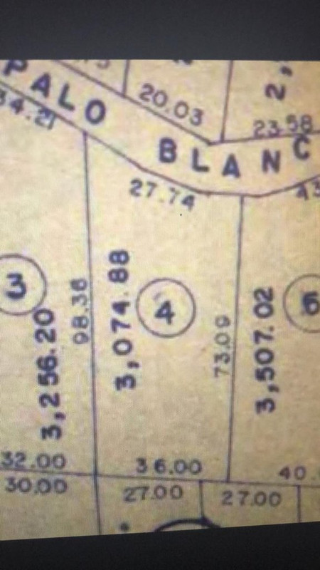
Hoping someone can help me with this, as I’m utterly hopeless at this stuff.

If I have an area of land with the following measurements:

Front: 27.74 metres
Rear: 36.00 metres
Side 1: 98.36 metres
Side 2: 73.09 metres

Is there any way that with these measurements, the total area of the land could be 3,074.88 square metres?

Thanks in advance
 
That looks about right. It's not quite a square, and if it was multiplying the longest two sides 36 x 98.36 gives 3,504 meters, so it'd would be less than that due to not being square.
 
It's a trapezoid, right? So you have to find its area (Base 1 + Base 2)/2 × height or A = (a+b)/2 × h
This is what it looks like according to the map, which I suspect may not be accurate. It’s number 4

272-F3215-8-DB2-422-B-9845-829-D6-FCECFA7.jpg
 
With a shape that irregular you won't be able to get an exact calculation of the area from only the lengths of the edges. But I'd say the answer to your question:

[..] Is there any way that with these measurements, the total area of the land could be 3,074.88 square metres?

is "yes".

As a quick approximation:

The 36m and 73.09m sides are at close to a right angle so they're a good fit for a simple approximation. Extend lines from the corners to form a rectangle and that rectangle would cover most of the area of the land. It wouldn't include some on the left (the left and right boundaries aren't quite parallel), the top and especially the top left, but it would include most of it. 36*73.09 = 2631.24. So the area would be somewhat more than 2631m^2 but not a huge amount more. 3074.88 m^2 would fit the bill.

Another quick approximation as a check:

Same idea but with the longer side gives 3541m^2 as the area of a rectangle somewhat bigger than the actual area. So the area is somewhat more than 2631m^2 and somehat less than 3541m^2. 3074.88m^2 still fits the bill.

Something is bothering me about the image, though. The top boundary is stated to be 27.74m long but it's longer on the image than the bottom boundary, which is stated to be 36m long. So the image can't be an accurate depiction of the shape of the area of land.
 
With a shape that irregular you won't be able to get an exact calculation of the area from only the lengths of the edges. But I'd say the answer to your question:

is "yes".

As a quick approximation:

The 36m and 73.09m sides are at close to a right angle so they're a good fit for a simple approximation. Extend lines from the corners to form a rectangle and that rectangle would cover most of the area of the land. It wouldn't include some on the left (the left and right boundaries aren't quite parallel), the top and especially the top left, but it would include most of it. 36*73.09 = 2631.24. So the area would be somewhat more than 2631m^2 but not a huge amount more. 3074.88 m^2 would fit the bill.

Another quick approximation as a check:

Same idea but with the longer side gives 3541m^2 as the area of a rectangle somewhat bigger than the actual area. So the area is somewhat more than 2631m^2 and somehat less than 3541m^2. 3074.88m^2 still fits the bill.

Something is bothering me about the image, though. The top boundary is stated to be 27.74m long but it's longer on the image than the bottom boundary, which is stated to be 36m long. So the image can't be an accurate depiction of the shape of the area of land.

Thanks, that's really helpful. Your last point is why I said the image may not be accurate. We are having another study done by an engineer to find the actual boundaries and area, I just wanted to make sure first that the measurements on the map (which match what I have in the deeds) have the potential to be accurate. The last study we had done put the front at almost 34m, which is closer to what the drawing of the map makes it look like, but doesn't match the measurements on the map or in the deeds. Luckily we haven't built anything apart from a chain link fence and a part of a wall in the disputed area, but the owner of the neighboring land obviously wants to get this sorted once and for all, as do I.
 
@geekman google maps mate, go to the measuring tool and plot out the perimeter and it gives the internal area.
I've traced it out on google maps but for some reason it isn't giving me the area. I must be doing something wrong.

Edit: ignore me, I worked it out
 
I've traced it out on google maps but for some reason it isn't giving me the area. I must be doing something wrong.

Edit: ignore me, I worked it out

lol. Was just ninjaing to try and find the place - got the area you need?
 
lol. Was just ninjaing to try and find the place - got the area you need?

Yes, and it's really interesting, so thanks for that. Not sure how accurate Google actually is, but I've suspected for a long time that the only measurement on that map I uploaded which is actually accurate is the back one, and Google confirms that. Tracing out the area of the land from the boundaries we have now, which are visible on Google, it gives me 2716m2, not the 3074m2 I'm supposed to have. If I modified the front line on google so that the front is 27.74 and keep the rear at 36, then connect the shape, that gives me 2154.65m2, which is even lower than what Google says I have right now, and vastly lower than the 3074m2 I'm supposed to have in the deeds.

The other strange thing is that the engineer we hired and the engineer the previous owner hired both put the front boundary in the same place, which makes it far longer than the 27m2 in the deeds. The first one is retired, and our one is being supremely unhelpful, so it should be interesting to see what the new one we hire says. The whole thing makes no sense to me.

It's pretty accurate. I used it as my unofficial management tool at work. If I need to quickly provide a client or subby with an area I can quickly measure up on maps instead of having to pull up my reference drawings, I tend to measure it against a building that I know the dimensions of (normally because I designed them).
 
It's pretty accurate. I used it as my unofficial management tool at work. If I need to quickly provide a client or subby with an area I can quickly measure up on maps instead of having to pull up my reference drawings, I tend to measure it against a building that I know the dimensions of (normally because I designed them).

I've just measured two other places I know the dimensions of, and it's almost 100% accurate. When I measure my land and the land of the neighbours however, they are totally different to the plan / deeds.
 
Back
Top Bottom