

Todays pic is another close to home view, imo an awe inspiring impressive view of our own planet.
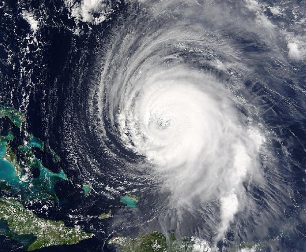
Hurricane Isabel Approaches
Where will Hurricane Isabel go? One of the stronger storm systems of modern times appears headed for one the more populated seaboards on planet Earth -- the east coast of the USA. Hurricane Isabel, pictured on the 15th September as it passed east of the Bahamas, has flirted with category 5 status, the most powerful hurricane category. Hurricanes are huge swirling storms with cloud systems typically larger than a state. Tropical cyclones, called hurricanes in Earth's Western Hemisphere and typhoons in the Eastern Hemisphere, get their immense energy from warm evaporated ocean water. As this water vapor cools and condenses, it heats the air, lowers pressure and hence causes cooler air to come swooshing in. Winds can reach over 250 kilometers per hour and become very dangerous. Much remains unknown about cyclones, including how they are formed and the exact path they will take.
A larger version of this piccy can be found here, this is a 817K Jpeg image; imo well worth grabbing and adjusting to use as a desktop wallpaper.
Credit: Terra Satellite, EOS, NASA
Previous Pic Of The Day posts
30th Aug 03
29th Aug 03 Courtesy of Biffa") (56K warning)
(56K warning)
25th Aug 03
21st Aug 03
Hurricane Isabel Approaches
Where will Hurricane Isabel go? One of the stronger storm systems of modern times appears headed for one the more populated seaboards on planet Earth -- the east coast of the USA. Hurricane Isabel, pictured on the 15th September as it passed east of the Bahamas, has flirted with category 5 status, the most powerful hurricane category. Hurricanes are huge swirling storms with cloud systems typically larger than a state. Tropical cyclones, called hurricanes in Earth's Western Hemisphere and typhoons in the Eastern Hemisphere, get their immense energy from warm evaporated ocean water. As this water vapor cools and condenses, it heats the air, lowers pressure and hence causes cooler air to come swooshing in. Winds can reach over 250 kilometers per hour and become very dangerous. Much remains unknown about cyclones, including how they are formed and the exact path they will take.
A larger version of this piccy can be found here, this is a 817K Jpeg image; imo well worth grabbing and adjusting to use as a desktop wallpaper.
Credit: Terra Satellite, EOS, NASA
Previous Pic Of The Day posts
30th Aug 03
29th Aug 03 Courtesy of Biffa
(56K warning)25th Aug 03
21st Aug 03

