Question re curvature of the earth

Caporegime
Joined
3 Jan 2006
Posts
25,244
Location
Chadderton, Oldham
From here in London, looking in a straight line north, York would not be in direct line of site due to the curvature of the earth.

So I'm wondering, how many feet or meters am I above, or below York due to the curvature of the earth?
 
It makes no sense to talk about above because there is no clear reference frame here. What you seem to be asking is how much slower to the north pole you are.
Above./height is defined by a vector point out of the center of the earth relative to the mean earth surface at that geolocation (the earth is to a true sphere). Hence latitude is irrelevant.
 
Last edited:
Ok assuming the north pole is higher, what altitude is it at, taking into account the curvature of the earth not ground level.
 
I assume what hes asking - if your looking north to the horizon how far below the horizon York would actually be.
 
It makes no sense to talk about above because there is no clear reference frame here. What you seem to be asking is how much slower to the north pole you are.

Slower to the north pole? What on earth does that mean?


What I think hes asking is, if you were to orient London as the 'north pole' of a sphere, and use a Cartesian measurement system, how far 'south' is York.
 
It just doesn't make sense. The north pole is at sea level so 0m.

That is not the answer you want but height has nothing to do with this. Sydney austrialia could be considered 'higher' than London by your logic.

The north pole is not "up", "top of the world" "highest point". It is just one end of the meomagnetic dipole. Antarctica is equally considered the "top of the world".

York is like 180 miles north of London! I.e closer to north pole.
 
Do you mean if you were to tunnel a straight line from London to York then at what depth would the middle part of the tunnel be underground?

Assuming this is the case then you need to calculate -

The radius at the two cities using their long/lat + their height above sealevel. Then if you take the distance between the two cities as the distance on the circumference then you are well on your way.
 
Last edited:
Divide half of Earth's circumference by the distance to York. Divide Earth's diameter by that number.

Note: almost certainly doesn't work :p
 
Do you mean if you were to tunnel a straight line from London to York then at what depth would the middle part of the tunnel be underground?

Yeah that's what I thought when first reading the question.

kHc4k.png
 
you know a priori radius of earth and arc length york->london.

calculate chord length

Use chord (c) as hypotenuse of a right-angled triangle.
calculate angle between line Y -> E and E -> L (call it theta)

Y = york,
E = earth centre
L = london

smallest angle of our right-angled triangle (alpha) is 90 - (180 - theta)/2

height diff, h, can then be obtained from

h/sin(alpha) = c / sin(pi/2)


sin(pi/2) =1


correct me if I'm wrong...


assumptions:
-spherical earth
-height above/below is relative to a tangent plane at a point of york/london.

The latter point I think is what the op is getting at - it will reveal how high something has to be to be seen by line of sight by someone at zero height in the other location
 
Last edited:
It just doesn't make sense. The north pole is at sea level so 0m.

That is not the answer you want but height has nothing to do with this. Sydney austrialia could be considered 'higher' than London by your logic.

The north pole is not "up", "top of the world" "highest point". It is just one end of the meomagnetic dipole. Antarctica is equally considered the "top of the world".

York is like 180 miles north of London! I.e closer to north pole.

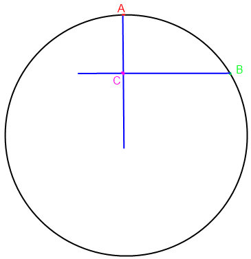
Thats using the radial co-ordinate system. I was trying to explain something like this:
crude.png


Where the distance AC is what the OP is asking
 
Back
Top Bottom