WORLD WEATHER THREAD

682717mainisaacnight102.jpg
Hurricane Isaac at Night

Early on August 29, 2012, the Visible Infrared Imaging Radiometer Suite on the Suomi-NPP satellite captured this nighttime view of Hurricane Isaac and the cities near the Gulf Coast of the United States. The image was acquired at 1:57 a.m. local time by the VIIRS "day-night band," which detects light in a range of wavelengths from green to near-infrared and uses light intensification to enable the detection of dim signals. In this case, the clouds of Isaac were lit by moonlight.
 
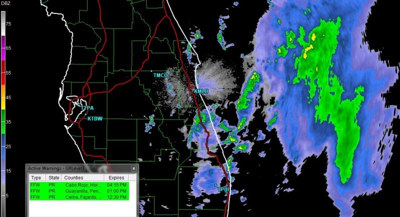
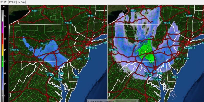
Has the eye of the hurricane hit New Orleans yet?

It's well past but the worst of the damage has just happened. Mostly downed power lines and flooding so far. The storm surge made it into Lake Pontchartrain and the north shore has taken a pounding, with Slidell getting some bad flooding. There were last minute mandatory evacuations in Tangipahoa Parish due to flash flooding and damaged levees.

New Orleans is getting back on it's feet. Entergy are getting power back on for a lot of people and the dusk-dawn curfew has been lifted. Downed trees are beign lifted and it looks like they're already fixing traffic lights and that sort of thing too. A lot of people are returning today.
 
Blackheath Major Snow Fall Event Summary - 12 Oct 2012


The video was taken in the town of Blackheath which is located in the Blue Mountains in the State of New South Wales in Australia. Blackheath's maximum altitude is 1098m (or 3602 feet) above sea level. Blackheath is located about 90kms (56 miles) north west of the City of Sydney.
 
Just a heads up to anyone interested, but I am planning on updating this thread from time to time to cover extreme weather events in the USA. I am an amateur meterogologist and intend to start updating this thread with extreme weather events that may occur at the start of the next spring storm season beginning approximately in April 2013.

I use some weather radar software for real tme analysis of storm systems, including reflectivity and velocity radar scans of which I plan to upload interesting radar images. I also use online weather data, including prediction models which I also plan on uploading to here to demonstrate the prediction and science behind prediciting when and where severe weather may strike, and may some real time stream links to some amateur and professional storm chasers in the USA.

In the end, I hope it will be informative, tie in with real events and link it to science with the weather models and real time radar imagery.

I may then extend this through to the hurricane season also, though my knowledge isn't as strong with hurricanes.
 
Looks like FL is going to be missed entirely and the latest projections put Sandy to make landfall on Monday/Tuesday, probably as a tropical storm around the New Jersey area.

SandyFL.jpg


The US is getting lots of rainfall across the country right now which will be pleasing for the drought affected areas:

octrain.jpg


More tropical storms have just swept out over Puerto Rico too, with risk of coastal flash flooding:

peurtorico.jpg
 
NOAA's GOES-13 satellite visible image of Sandy on Oct. 28:

701091main20121028sandy.jpg

Animation of observations from NOAA's GOES-13 satellite (Oct. 26-28):

 
Some heavy rainfall sweeping across PA at the moment as seen by the rainfall calculation models at the moment. Just the outer bands of Sandy sweeping the east coast now. See below hourly rainfall on the left, reflectivity on the right:

PA1.jpg


New York state currently being washed by a persistent rain band that has swept across the states over the past few days and should collide with Sandy shortly hourly Rainfall on left, reflectivity on right:

NY1.jpg


The following outlines all major weather alerts currently in place. A large storm surge is expected and Sandy appears to be strengthening a bit more. Currently predicts 80-90mph winds in the centre. Probably a 1 in 50 year storm.

Active alerts:

activealerts1.jpg


And reflectivity of wider USA:

radar1.jpg
 
Last edited:
Back
Top Bottom