Soldato
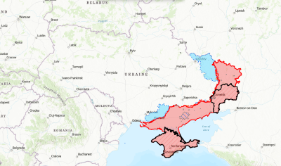
There are quite a few, but you have to take them with a large pinch of salt as they are all created using open source intelligence, therefore subject to inaccuracies, untimely reporting and only using information publicly available and for the most part confirmed data. Also please note that using these maps will generally give you a false impression of a largely static front with clear boundaries, which just isnt the case, these fronts will be for the most part fluid, lots of gains and losses along the lines daily/hourly.Is there's anyway to see a front line illustration. The news recently has been filled with Ukraine making headway into the donbas/Crimea area but I'd like help visualising an actual me understand how this is panning out.

Ukraine Interactive map - Ukraine Latest news on live map - liveuamap.com
Live Universal Awareness Map Liveuamap is a leading independent global news and information site dedicated to factual reporting of a variety of important topics including conflicts, human rights issues, protests, terrorism, weapons deployment, health matters, natural disasters, and weather...

Maps | MilitaryLand.net
Maps of Russian Invasion of Ukraine, deployment map of Ukrainian units and more.
 militaryland.net

Interactive Map: Russia's Invasion of Ukraine
This interactive map complements the static control-of-terrain maps that ISW daily produces with high-fidelity.


