

You are using an out of date browser. It may not display this or other websites correctly.
You should upgrade or use an alternative browser.
You should upgrade or use an alternative browser.
Winter 2020/2021
- Thread starter Neil79
- Start date
More options
Thread starter's postsSnowing in Newcastle Upon Tyne pretty decent amount coming down but it's already wet so bleh..
noticed they were salting the roads last night, I say salting cos it seems to be just salty water coming out the back of the trucks rather than actual grit
noticed they were salting the roads last night, I say salting cos it seems to be just salty water coming out the back of the trucks rather than actual grit
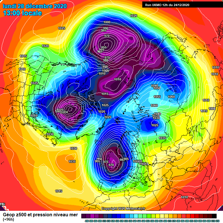
We have had cross model agreement for a few days now, the cool pool to the north has been well and truly tapped into and the jet is firmly to the south.
This cold pool could well dig south if we get ridging either side, hopefully bringing a prolonged spell.
All of this before we even start to mention the current strat warming!
This cold pool could well dig south if we get ridging either side, hopefully bringing a prolonged spell.
All of this before we even start to mention the current strat warming!

 I might not even put my winter coat on, just gloves and hat.
We have had cross model agreement for a few days now, the cool pool to the north has been well and truly tapped into and the jet is firmly to the south.
This cold pool could well dig south if we get ridging either side, hopefully bringing a prolonged spell.
All of this before we even start to mention the current strat warming!
Is there actually the cold there though? the setup in years gone by would bring substantial wintery weather but from what I can see the depth of cold just isn't there yet.
I have no idea what is going on with the polar vortex but there is definitely some drama up there over the next few weeks on the models - though looks like any major outcome from it will favour North America yet again.
The dew points and uppers are looking good, 2m temps look fine but there's bound to be a correction or two that pushes the low where we don't want it.
I'm a coldie so tend to ignore the milder outputs lol
I almost guarantee it will snow around the 7th when I have my MOT
 as I've had it delayed and cancelled more than once due to COVID situations at the garages and now running out of time.
Tuesday 29 Dec - Thursday 7 Jan
Staying unsettled through the end of December with a mixture of sunny spells and showers, but also some longer spells of precipitation. Temperatures are expected to be below average with snow across the hills but also likely to lower levels at times, especially but not restricted to the north. At times it will be windy with a risk of coastal gales, with central and eastern areas likely to witness more in the way of lighter winds, bringing the risk of fog. Into early January there are signs that higher pressure may start to build from the southwest bringing more settled weather. Should this occur, overnight frosts will become more widespread with the risk of morning fog patches. Temperatures are likely to remain below average through this period with wintry hazards.
Thursday 7 Jan - Thursday 21 Jan
A continuation of rather cold conditions looks most likely into early January and towards the middle part of January. This would bring periods of fine and dry weather with western areas likely to be drier than average and eastern areas at risk of wintry showers. From mid-January onwards confidence is low however similar conditions are most probable with winds most likely from a northerly quadrant, bringing below average temperatures and wintry hazards at times. However there still remains the possibility of conditions turning more unsettled and milder through the second half of January.
https://www.metoffice.gov.uk/
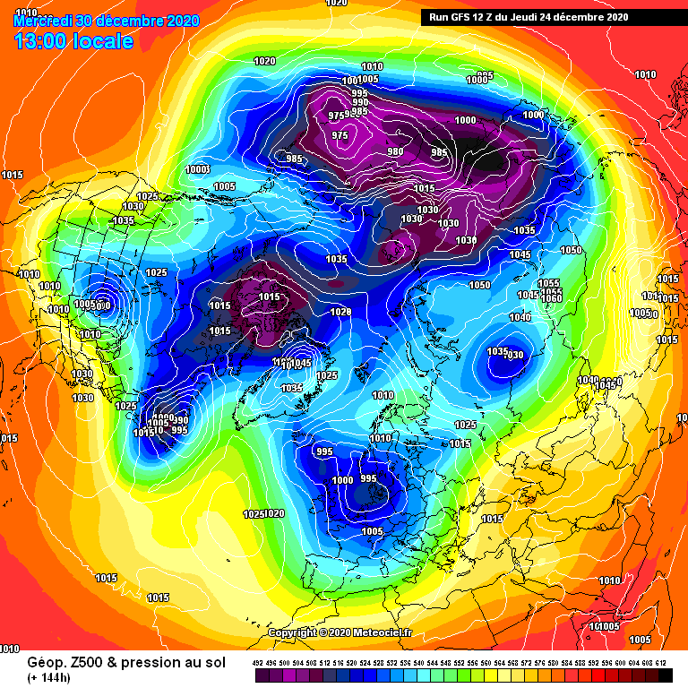
The GFS mean shows a positive outlook in terms of both short term and mid term cold. The Atlantic is flat and currently of no threat, although from experience those familiar with UK weather will understand that the Atlantic is never 100% asleep.
Sunday night into Monday morning looks VERY interesting, parts of the south east could see good snowfall.
Sunday night into Monday morning looks VERY interesting, parts of the south east could see good snowfall.
So very high wind warning from about 1 pm tomorrow ,batten down the hatches and all that ,stayed local a place called case hill ,looking towards Rough tor (pronounced row as in argument) and brown willy ,calm before the storm

The GFS mean shows a positive outlook in terms of both short term and mid term cold. The Atlantic is flat and currently of no threat, although from experience those familiar with UK weather will understand that the Atlantic is never 100% asleep.
Sunday night into Monday morning looks VERY interesting, parts of the south east could see good snowfall.
The Atlantic has a bad habit of being a spoil sport.
Unless I see sub -10 850hPa and the jet well south of us I don't have any expectations these days of anything beyond isolated snow over high ground, etc.
Man of Honour
- Joined
- 21 Nov 2004
- Posts
- 46,381
Snow tomorrow 
The Atlantic has a bad habit of being a spoil sport.
Unless I see sub -10 850hPa and the jet well south of us I don't have any expectations these days of anything beyond isolated snow over high ground, etc.
We don't need -10 uppers, and the jet is long gone and banished.
The pending snowfall is going to be nowcast, ICON, GFS, UKMO, Harmonie, Arpege etc are all showing a different output.
Forecast sleet here and a 'real feel' of -3 for tomorrow, best wear my thermals!
 Am really glad am not working tomorrow...
Really not looking forward to going back to work on Tuesday being freezing cold & wet all day